


Mont-Saint-Guilbert_02

denissculier
User
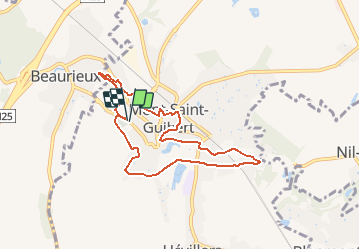

Length
7 km

Max alt
117 m

Uphill gradient
110 m
Km-Effort
8.5 km

Min alt
73 m

Downhill gradient
110 m
Boucle
Yes
Creation date :
2019-01-15 18:20:16.144
Updated on :
2021-04-27 08:05:58.41
1h54
Difficulty : Medium

FREE GPS app for hiking
 SityTrail
IGN / Geographical institutes
SityTrail Plus
The world is yours!
About
Trail Nordic walking of 7 km to be discovered at Wallonia, Walloon Brabant, Mont-Saint-Guibert. This trail is proposed by denissculier.
Positioning
Country:
Belgium
Region :
Wallonia
Department/Province :
Walloon Brabant
Municipality :
Mont-Saint-Guibert
Location:
Mont-Saint-Guibert
Start:(Dec)
Start:(UTM)
613563 ; 5610601 (31U) N.
Comments