


Cucuron 10 km

Lobin
User
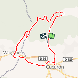

Length
10.3 km

Max alt
581 m

Uphill gradient
337 m
Km-Effort
14.7 km

Min alt
344 m

Downhill gradient
336 m
Boucle
Yes
Creation date :
2019-01-15 18:20:19.436
Updated on :
2019-01-15 18:20:19.436
2h56
Difficulty : Medium

FREE GPS app for hiking
 SityTrail
IGN / Geographical institutes
SityTrail Plus
The world is yours!
About
Trail Walking of 10.3 km to be discovered at Provence-Alpes-Côte d'Azur, Vaucluse, Cucuron. This trail is proposed by Lobin.
Positioning
Country:
France
Region :
Provence-Alpes-Côte d'Azur
Department/Province :
Vaucluse
Municipality :
Cucuron
Location:
Unknown
Start:(Dec)
Start:(UTM)
695912 ; 4850628 (31T) N.
Comments