Trail Walking Boulogne-Billancourt - Parc de St Cloud et forêt de Fausses Reposes - Photo

Parc de St Cloud et forêt de Fausses Reposes

 tracegps
tracegps

User

© OpenStreetMap contributors
Length
Length
18.2 km
Max alt
Max alt
184 m
Uphill gradient
Uphill gradient
384 m
Km-Effort
Km-Effort  
23 km
Min alt
Min alt
20 m
Downhill gradient
Downhill gradient
304 m
Boucle
Boucle
No
Creation date :
2014-12-10 00:00:00.0
Updated on :
2014-12-10 00:00:00.0

(1 Reviews)

Walking
Walking
4h30
Difficulty : Medium

Scan this QR Code to open this trail in the SityTrail application

FREE GPS app for hiking

Logo SityTrail SityTrail

IGN / Geographical institutes

Download SityTrail from the App Store Download SityTrail from Google Play

Logo SityTrail SityTrail World

The world is yours!

Download SityTrail from the App Store Download SityTrail from Google Play Download SityTrail on Huawei AppGallery

About

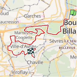
Trail Walking of 18.2 km to be discovered at Ile-de-France, Hauts-de-Seine, Boulogne-Billancourt. This trail is proposed by tracegps.

Description

Départ au Métro Pont de St Cloud, arrivée à la Gare de Chaville RD. Nous traversons d'abord le Parc de St Cloud puis nous gagnons la forêt de Fausses Reposes par Sévres et le mail Corot. Nous passerons aux étangs de Ville d'Avray et au Haras de Jardy avant de rejoindre enfin la gare de Chaville par les sous-bois. Pour tout renseignement supplémentaire: danielyvesbaijot(at)yahoo.fr

Elevation profile

Photos

Positioning

Country:
France
Region :
Ile-de-France
Department/Province :
Hauts-de-Seine
Municipality :
Boulogne-Billancourt
Location:
Unknown
Start:(UTM)
443287 ; 5410062 (31U) N.

Comments

Please log in to post a review or rate the element


Trails nearby

Trail Walking Chaville - Le Sentier des 7 étangs - Photo
Walking
tracegps

Walking

Difficult
(5)
Chaville, Ile-de-France, Hauts-de-Seine, France
23 km | 31 km-effort
5h 0min
Yes
Trail Walking Paris - 010 - Paris - des serres d'Auteuil à Bagatelle  - Photo
Walking
GUIDE
Rui Barbosa

Walking

Difficult
(1)
Paris, Ile-de-France, Paris, France
12.3 km | 14 km-effort
3h 10min
No
Trail Walking Paris - DP75-11 De Boulainvilliers à pont du Garigliano - Photo
Walking
clalaur

Walking

Easy
(1)
Paris, Ile-de-France, Paris, France
4.7 km | 5.4 km-effort
1h 13min
No
Trail Walking Paris - DP75-19 de Porte-Maillot à Europe - Photo
Walking
clalaur

Walking

Easy
(1)
Paris, Ile-de-France, Paris, France
4.2 km | 4.8 km-effort
1h 5min
No
Trail Cycle Paris - Paris au bord de Seine - Photo
Cycle
aurel911

Cycle

Very easy
(1)
Paris, Ile-de-France, Paris, France
11.4 km | 14.2 km-effort
46min
No
Trail On foot Paris - 004 - Paris - Petite Ceinture Sud - Photo
On foot
GUIDE
Rui Barbosa

On foot

Easy
(1)
Paris, Ile-de-France, Paris, France
10.5 km | 12.2 km-effort
2h 46min
No
Trail Walking Paris - 75-05-Paris les Boulevards 13km-625-799- - Photo
Walking
rvs147

Walking

Easy
(1)
Paris, Ile-de-France, Paris, France
12.7 km | 15.4 km-effort
3h 12min
Yes
Trail Walking Paris - 75-04-Paris les Ponts 13km-493-55- - Photo
Walking
rvs147

Walking

Easy
(1)
Paris, Ile-de-France, Paris, France
13.1 km | 16.3 km-effort
3h 22min
No
Trail Walking Viroflay - Les 3 Forêts; Meudon, Fausses Reposes et Versailles - Photo
Walking
tracegps

Walking

Difficult
(2)
Viroflay, Ile-de-France, Yvelines, France
25 km | 32 km-effort
5h 19min
Yes


Close
My subscriptions