


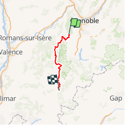
Raid des Chemins du Soleil 2011 - Villard de Lans à Luc en Diois

tracegps
User


8h00
Difficulty : Very difficult

FREE GPS app for hiking
 SityTrail
IGN / Geographical institutes
SityTrail Plus
The world is yours!
About
Trail Mountain bike of 95 km to be discovered at Auvergne-Rhône-Alpes, Isère, Villard-de-Lans. This trail is proposed by tracegps.
Description
Première partie du Raid des Chemins du Soleil 2011. Départ de Villard de Lans arrivée à Luc en Diois. Un peu de portage et super descente sur la massif du Glandasse. Nombreuses parties techniques, pour vttiste bien entrainé.
Photos

Positioning
Comments