Trail Mountain bike Bellerive-sur-Allier - VTT - L'Évasion Bellerivoise - Bellerive sur Allier - Photo

VTT - L'Évasion Bellerivoise - Bellerive sur Allier

 tracegps
tracegps

User

© OpenStreetMap contributors
Length
Length
57 km
Max alt
Max alt
387 m
Uphill gradient
Uphill gradient
780 m
Km-Effort
Km-Effort  
67 km
Min alt
Min alt
272 m
Downhill gradient
Downhill gradient
780 m
Boucle
Boucle
Yes
Creation date :
2014-12-10 00:00:00.0
Updated on :
2014-12-10 00:00:00.0

(0 Reviews)

Mountain bike
Mountain bike
3h45
Difficulty : Difficult

Scan this QR Code to open this trail in the SityTrail application

FREE GPS app for hiking

Logo SityTrail SityTrail

IGN / Geographical institutes

Download SityTrail from the App Store Download SityTrail from Google Play

Logo SityTrail SityTrail World

The world is yours!

Download SityTrail from the App Store Download SityTrail from Google Play Download SityTrail on Huawei AppGallery

About

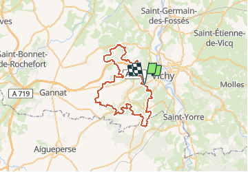
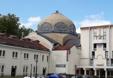
Trail Mountain bike of 57 km to be discovered at Auvergne-Rhône-Alpes, Allier, Bellerive-sur-Allier. This trail is proposed by tracegps.

Description

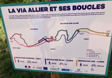
Parking et départ de la salle "Monzière" qui se trouve sur la route de "Serbannes" (au sud-ouest de Bellerive-sur-Allier). Cette randonnée, organisée par le Club VTT de Bellerive, s'est déroulée le dimanche 19 juin 2011. Ce Club est composé de membres conviviaux, sympathiques et attachants. Un nouveau circuit est proposé chaque année. L'édition 2011 était très facile. Ce parcours qui est très roulant pourrait sembler très ennuyeux, mais bien au contraire, il est rythmé par des passages en sous-bois très ludiques et ponctuellement un peu techniques. Topoguide : Autour de Vichy, balades et randonnées à pied et à VTT (35 circuits)

Elevation profile

Photos

Positioning

Country:
France
Region :
Auvergne-Rhône-Alpes
Department/Province :
Allier
Municipality :
Bellerive-sur-Allier
Location:
Unknown
Start:(UTM)
529692 ; 5106318 (31T) N.

Trails nearby

Trail Running Bellerive-sur-Allier - jour 9 CAP Jeanot - Photo
Running
jeannat

Running

Very easy
Bellerive-sur-Allier, Auvergne-Rhône-Alpes, Allier, France
29 km | 33 km-effort
3h 5min
No
Trail Mountain bike Vichy - Rives et Boires de l'Allier - Photo
Mountain bike
tracegps

Mountain bike

Easy
(1)
Vichy, Auvergne-Rhône-Alpes, Allier, France
19.9 km | 21 km-effort
1h 45min
Yes
Trail Walking Vichy - Vichy - Photo
Walking
emileverschueren

Walking

Easy
Vichy, Auvergne-Rhône-Alpes, Allier, France
4 km | 4.2 km-effort
1h 58min
No
Trail Walking Vichy - Vichy - Photo
Walking
guy63

Walking

Medium
Vichy, Auvergne-Rhône-Alpes, Allier, France
8.5 km | 9.2 km-effort
3h 40min
Yes
Trail Walking Vichy - vichy Historique  - Photo
Walking
guy63

Walking

Very easy
Vichy, Auvergne-Rhône-Alpes, Allier, France
7.7 km | 8.6 km-effort
2h 42min
Yes
Trail Cycle Vichy - Vichy Oleron Rochefort - Photo
Cycle
tracegps

Cycle

Medium
Vichy, Auvergne-Rhône-Alpes, Allier, France
551 km | 639 km-effort
50h 0min
No
Trail Walking Bellerive-sur-Allier - boucles des îles abrest  - Photo
Walking
Celine Thomas

Walking

Easy
Bellerive-sur-Allier, Auvergne-Rhône-Alpes, Allier, France
15.9 km | 17.3 km-effort
3h 35min
Yes
Trail Walking Vichy - on LUI a consacré une heure, on ne L´a jamais trouvé  - Photo
Walking
stef789

Walking

Easy
Vichy, Auvergne-Rhône-Alpes, Allier, France
2.1 km | 2.3 km-effort
1h 0min
Yes
Trail Walking Bellerive-sur-Allier - Boucle des îles Vichy on a fait un Web très bien non on a failli y aller c’était Plaza y avait c’était fermé - Photo
Walking
ezola

Walking

Very difficult
Bellerive-sur-Allier, Auvergne-Rhône-Alpes, Allier, France
18.9 km | 21 km-effort
4h 3min
Yes


Close
My subscriptions