Trail Walking Cattenières - De Cattenières à Estourmel par Carnieres - Photo

De Cattenières à Estourmel par Carnieres

 tracegps
tracegps

User

© OpenStreetMap contributors
Length
Length
15.1 km
Max alt
Max alt
104 m
Uphill gradient
Uphill gradient
128 m
Km-Effort
Km-Effort  
16.8 km
Min alt
Min alt
63 m
Downhill gradient
Downhill gradient
128 m
Boucle
Boucle
Yes
Creation date :
2014-12-10 00:00:00.0
Updated on :
2014-12-10 00:00:00.0

(0 Reviews)

Walking
Walking
2h45
Difficulty : Easy

Scan this QR Code to open this trail in the SityTrail application

FREE GPS app for hiking

Logo SityTrail SityTrail

IGN / Geographical institutes

Download SityTrail from the App Store Download SityTrail from Google Play

Logo SityTrail SityTrail World

The world is yours!

Download SityTrail from the App Store Download SityTrail from Google Play Download SityTrail on Huawei AppGallery

About

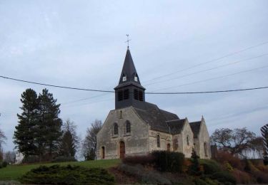
Trail Walking of 15.1 km to be discovered at Hauts-de-France, Nord, Cattenières. This trail is proposed by tracegps.

Description

Petite balade de 15 km dans le Cambresis.

Elevation profile

Positioning

Country:
France
Region :
Hauts-de-France
Department/Province :
Nord
Municipality :
Cattenières
Location:
Unknown
Start:(Dec)
Start:(UTM)
523728 ; 5554015 (31U) N.

Trails nearby

Trail Walking Esnes - Du château d'Esnes à l'abbaye des Guillemins  -  Esnes    - Photo
Walking
tracegps

Walking

Medium
(1)
Esnes, Hauts-de-France, Nord, France
11.4 km | 13 km-effort
2h 49min
Yes
Trail Walking Carnières - Circuit des 2 tours - Carnières - Photo
Walking
tracegps

Walking

Medium
Carnières, Hauts-de-France, Nord, France
10.6 km | 11.8 km-effort
2h 40min
Yes
Trail Cycle Fontaine-au-Pire - Les Mulquiniers: Panorama du Cambresis - Photo
Cycle
tracegps

Cycle

Medium
Fontaine-au-Pire, Hauts-de-France, Nord, France
39 km | 43 km-effort
3h 30min
Yes
Trail Cycle Carnières - Les Mulquiniers: Pays des Riots - Photo
Cycle
tracegps

Cycle

Medium
Carnières, Hauts-de-France, Nord, France
36 km | 40 km-effort
2h 30min
Yes
Trail Walking Wambaix - Randonnée de 12.5 km en partant de Wambaix - Photo
Walking
tracegps

Walking

Easy
Wambaix, Hauts-de-France, Nord, France
12.5 km | 14.3 km-effort
2h 15min
Yes
Trail Walking Caudry - Randonnée de 16 km en partant de Caudry - Photo
Walking
tracegps

Walking

Medium
Caudry, Hauts-de-France, Nord, France
16.2 km | 17.8 km-effort
2h 30min
Yes
Trail Walking Fontaine-au-Pire - 22.5km en partant de Fontaine au Pire - Photo
Walking
tracegps

Walking

Medium
Fontaine-au-Pire, Hauts-de-France, Nord, France
21 km | 24 km-effort
3h 30min
Yes
Trail Walking Beauvois-en-Cambrésis - Beauvais en cambresi  59  19/04/2019 - Photo
Walking
papajp

Walking

Beauvois-en-Cambrésis, Hauts-de-France, Nord, France
3.6 km | 3.9 km-effort
1h 6min
Yes
Trail Walking Beauvois-en-Cambrésis - bauvois en Cambresis  - Photo
Walking
papajp

Walking

Very easy
Beauvois-en-Cambrésis, Hauts-de-France, Nord, France
2.6 km | 0 m-effort
48min
No


Close
My subscriptions