GR 223 - de Cherbourg à Flamanville

tracegps
User
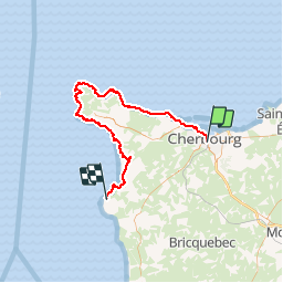

Length
70 km

Max alt
130 m

Uphill gradient
1270 m
Km-Effort
87 km

Min alt
-3 m

Downhill gradient
1223 m
Boucle
No
Creation date :
2014-12-10 00:00:00.0
Updated on :
2014-12-10 00:00:00.0
16h00
Difficulty : Medium

FREE GPS app for hiking
 SityTrail
IGN / Geographical institutes
SityTrail Plus
The world is yours!
About
Trail Walking of 70 km to be discovered at Normandy, Manche, Cherbourg-en-Cotentin. This trail is proposed by tracegps.
Positioning
Country:
France
Region :
Normandy
Department/Province :
Manche
Municipality :
Cherbourg-en-Cotentin
Location:
Cherbourg-Octeville
Start:(Dec)
Start:(UTM)
599520 ; 5498832 (30U) N.
Comments