


Cluny Rando des moines 2018

pensionisten71
User
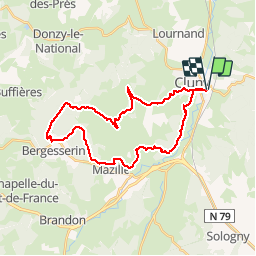

Length
30 km

Max alt
566 m

Uphill gradient
765 m
Km-Effort
41 km

Min alt
232 m

Downhill gradient
763 m
Boucle
Yes
Creation date :
2019-01-15 18:42:07.688
Updated on :
2019-01-15 18:42:07.688
6h03
Difficulty : Medium

FREE GPS app for hiking
 SityTrail
IGN / Geographical institutes
SityTrail Plus
The world is yours!
About
Trail Walking of 30 km to be discovered at Bourgogne-Franche-Comté, Saône-et-Loire, Cluny. This trail is proposed by pensionisten71.
Positioning
Country:
France
Region :
Bourgogne-Franche-Comté
Department/Province :
Saône-et-Loire
Municipality :
Cluny
Location:
Unknown
Start:(Dec)
Start:(UTM)
628186 ; 5143211 (31T) N.
Comments