


nemours sur loing

olivieraron
User
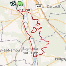

Length
19.6 km

Max alt
129 m

Uphill gradient
231 m
Km-Effort
23 km

Min alt
57 m

Downhill gradient
231 m
Boucle
Yes
Creation date :
2019-01-14 09:41:37.221
Updated on :
2019-01-14 09:41:37.247
6h40
Difficulty : Unknown

FREE GPS app for hiking
 SityTrail
IGN / Geographical institutes
SityTrail Plus
The world is yours!
About
Trail Other activity of 19.6 km to be discovered at Ile-de-France, Seine-et-Marne, Nemours. This trail is proposed by olivieraron.
Positioning
Country:
France
Region :
Ile-de-France
Department/Province :
Seine-et-Marne
Municipality :
Nemours
Location:
Unknown
Start:(Dec)
Start:(UTM)
476708 ; 5346147 (31U) N.
Comments