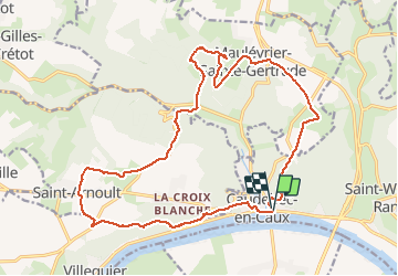
Trail Walking Rives-en-Seine - Caudebec en Caux - Photo
 tracegps
tracegps

User

© OpenStreetMap contributors
Length
Length
20 km
Max alt
Max alt
142 m
Uphill gradient
Uphill gradient
449 m
Km-Effort
Km-Effort  
26 km
Min alt
Min alt
4 m
Downhill gradient
Downhill gradient
442 m
Boucle
Boucle
Yes
Creation date :
2014-12-10 00:00:00.0
Updated on :
2014-12-10 00:00:00.0

(0 Reviews)

Walking
Walking
4h00
Difficulty : Medium

Scan this QR Code to open this trail in the SityTrail application

FREE GPS app for hiking

Logo SityTrail SityTrail

IGN / Geographical institutes

Download SityTrail from the App Store Download SityTrail from Google Play

Logo SityTrail SityTrail Plus

The world is yours!

Download SityTrail from the App Store Download SityTrail from Google Play Download SityTrail on Huawei AppGallery

About

Trail Walking of 20 km to be discovered at Normandy, Seine-Maritime, Rives-en-Seine. This trail is proposed by tracegps.

Description

Départ à Caudebec-en-Caux en bord de Seine. Cette balade en Forêt Domaniale du Trait-Maulévrier utilise en partie les GR2 et 211. Le parcours présente des paysages très variés et de magnifiques points de vue sur la Seine.

Elevation profile

Photos

Positioning

Country:
France
Region :
Normandy
Department/Province :
Seine-Maritime
Municipality :
Rives-en-Seine
Location:
Unknown
Start:(UTM)
335599 ; 5488278 (31U) N.


Close
My subscriptions