Trail Walking Rives-en-Seine - Balade à Villequier - Photo
 tracegps
tracegps

User

© OpenStreetMap contributors
Length
Length
9.7 km
Max alt
Max alt
150 m
Uphill gradient
Uphill gradient
209 m
Km-Effort
Km-Effort  
12.5 km
Min alt
Min alt
2 m
Downhill gradient
Downhill gradient
210 m
Boucle
Boucle
Yes
Creation date :
2014-12-10 00:00:00.0
Updated on :
2014-12-10 00:00:00.0

(1 Reviews)

Walking
Walking
2h00
Difficulty : Easy

Scan this QR Code to open this trail in the SityTrail application

FREE GPS app for hiking

Logo SityTrail SityTrail

IGN / Geographical institutes

Download SityTrail from the App Store Download SityTrail from Google Play

Logo SityTrail SityTrail World

The world is yours!

Download SityTrail from the App Store Download SityTrail from Google Play Download SityTrail on Huawei AppGallery

About

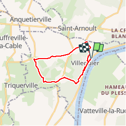
Trail Walking of 9.7 km to be discovered at Normandy, Seine-Maritime, Rives-en-Seine. This trail is proposed by tracegps.

Description

Nous commençons sur les quais de Villequier en bord de Seine. Nous passons devant la maison Vacquerie, Musée Victor Hugo, avec une pensée pour Léopoldine sous forme de concours de mémoire pour nos classiques : "Demain, dès l'aube, à l'heure où blanchit la campagne..." Nous montons vers Bébec. L'église du XVIème siècle mérite le petit détour. Nous passons devant le château de Villequier, le Séquoia de la Cour du Cèdre et redescendons vers Villequier. Toutes les photos sur balades en Normandie.

Elevation profile

Photos

Positioning

Country:
France
Region :
Normandy
Department/Province :
Seine-Maritime
Municipality :
Rives-en-Seine
Location:
Unknown
Start:(UTM)
331854 ; 5487280 (31U) N.

Comments

Please log in to post a review or rate the element


Trails nearby

Trail Walking Rives-en-Seine - 20220421-Caudebec en Caux Journée - Photo
Walking
doudet

Walking

Medium
Rives-en-Seine, Normandy, Seine-Maritime, France
21 km | 27 km-effort
6h 34min
Yes
Trail Walking Arelaune-en-Seine - Saint-Nicolas de Bliquetuit (Vers l'Armada) - Photo
Walking
MichelRando7656

Walking

Very easy
Arelaune-en-Seine, Normandy, Seine-Maritime, France
11.2 km | 12.2 km-effort
2h 32min
Yes
Trail Equestrian Port-Jérôme-sur-Seine - Autour de Triquerville à Cheval - Photo
Equestrian
tracegps

Equestrian

Medium
Port-Jérôme-sur-Seine, Normandy, Seine-Maritime, France
16.6 km | 20 km-effort
2h 30min
Yes
Trail Mountain bike Port-Jérôme-sur-Seine - Autour de Triquerville à Cheval - Photo
Mountain bike
tracegps

Mountain bike

Medium
Port-Jérôme-sur-Seine, Normandy, Seine-Maritime, France
16.6 km | 20 km-effort
1h 30min
Yes
Trail Mountain bike Vatteville-la-Rue - Randonnée en forêt de Brotonne - Photo
Mountain bike
tracegps

Mountain bike

Difficult
Vatteville-la-Rue, Normandy, Seine-Maritime, France
61 km | 73 km-effort
3h 30min
Yes
Trail Walking Rives-en-Seine - les hauts de caudebecq en caux - Photo
Walking
prv

Walking

Easy
Rives-en-Seine, Normandy, Seine-Maritime, France
10 km | 13.3 km-effort
2h 32min
Yes
Trail Walking Rives-en-Seine - Caudebec en Caux - Photo
Walking
tracegps

Walking

Medium
Rives-en-Seine, Normandy, Seine-Maritime, France
20 km | 26 km-effort
4h 0min
Yes
Trail Walking Norville - Randonnée autour de Norville - Photo
Walking
tracegps

Walking

Medium
(1)
Norville, Normandy, Seine-Maritime, France
13.4 km | 15.5 km-effort
2h 30min
No
Trail Walking Arelaune-en-Seine - saintnicolas de bliquetuit - Photo
Walking
CH CARRE

Walking

Easy
Arelaune-en-Seine, Normandy, Seine-Maritime, France
17.3 km | 18.6 km-effort
3h 16min
No


Close
My subscriptions