Trail Walking Peyruis - Peyruis, le tour de Tourdeaux - Photo
 tracegps
tracegps

User

© OpenStreetMap contributors
Length
Length
13.8 km
Max alt
Max alt
773 m
Uphill gradient
Uphill gradient
467 m
Km-Effort
Km-Effort  
20 km
Min alt
Min alt
409 m
Downhill gradient
Downhill gradient
477 m
Boucle
Boucle
Yes
Creation date :
2014-12-10 00:00:00.0
Updated on :
2014-12-10 00:00:00.0

(0 Reviews)

Walking
Walking
6h00
Difficulty : Medium

Scan this QR Code to open this trail in the SityTrail application

FREE GPS app for hiking

Logo SityTrail SityTrail

IGN / Geographical institutes

Download SityTrail from the App Store Download SityTrail from Google Play

Logo SityTrail SityTrail World

The world is yours!

Download SityTrail from the App Store Download SityTrail from Google Play Download SityTrail on Huawei AppGallery

About

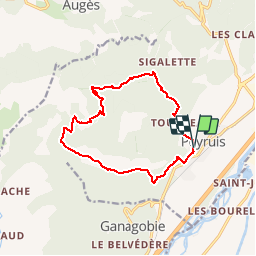
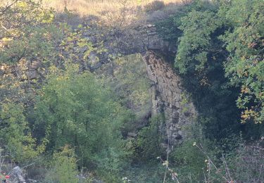
Trail Walking of 13.8 km to be discovered at Provence-Alpes-Côte d'Azur, Alpes-de-Haute-Provence, Peyruis. This trail is proposed by tracegps.

Description

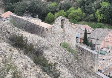
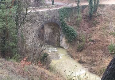
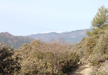
Stationnement, rue de la Calade au bas des escaliers qui montent au château. Montée par la route vers la bifurcation "Calade". Montée par la route vers le Jas des Agasses (ruines). Montée par un chemin vers la Chapelle des Auges (restaurée) où l'on peu admirer un superbe point de vue à 360°. Descente vers le Col Bas par un chemin. Promenade sur des chemins jusqu'à l'heure de la pause repas. Un peu de montée vers un petit plateau. Longue promenade vers la bifurcation, descente vers la vallée de la Durance et la bifurcation Bevon par des chemins. Plat jusqu'à l'Eglise St Roch. Centre ville jusqu'au retour aux voitures en passant par une particularité architecturale : une fenêtre d'angle. Un tout petit peu de route goudronnée, beaucoup de chemin de terre pour ce tour du Tourdreau.

Elevation profile

Photos

Points of interest

Point of interest Peyruis - Arrivée - Photo
tracegps
PEYRUIS 
Point of interest Peyruis - Bevon - Photo
tracegps
PEYRUIS 
Point of interest Peyruis - Calade - Photo
tracegps
PEYRUIS 
Point of interest Peyruis - Chapelles Auges - Photo
tracegps
Point of interest Peyruis - Col Bas - Photo
tracegps
PEYRUIS 
Point of interest Peyruis - Départ - Photo
tracegps
PEYRUIS 
Point of interest Peyruis - Eglise - Photo
tracegps
PEYRUIS 
Point of interest Peyruis - Jas Agasse - Photo
tracegps
PEYRUIS 
Point of interest Peyruis - Plateau - Photo
tracegps
PEYRUIS 
Point of interest Peyruis - Repas - Photo
tracegps
PEYRUIS 
Point of interest Peyruis - Repentance - Photo
tracegps
PEYRUIS 

Positioning

Country:
France
Region :
Provence-Alpes-Côte d'Azur
Department/Province :
Alpes-de-Haute-Provence
Municipality :
Peyruis
Location:
Unknown
Start:(UTM)
735415 ; 4879248 (31T) N.

Trails nearby

Trail Walking Les Mées - Les Mées - Malijai - Les Mées - Photo
Walking
tracegps

Walking

Medium
(1)
Les Mées, Provence-Alpes-Côte d'Azur, Alpes-de-Haute-Provence, France
12.1 km | 18.1 km-effort
4h 30min
Yes
Trail Walking Les Mées - Les Pénitents - circuit long - Les Mées - Photo
Walking
tracegps

Walking

Medium
(1)
Les Mées, Provence-Alpes-Côte d'Azur, Alpes-de-Haute-Provence, France
14.3 km | 21 km-effort
4h 0min
Yes
Trail Walking Les Mées - Les Pénitents - circuit court - Les Mées - Photo
Walking
tracegps

Walking

Medium
(2)
Les Mées, Provence-Alpes-Côte d'Azur, Alpes-de-Haute-Provence, France
5.8 km | 9.5 km-effort
2h 0min
Yes
Trail Walking Ganagobie - Plateau de Ganagobie - Photo
Walking
tracegps

Walking

Medium
(2)
Ganagobie, Provence-Alpes-Côte d'Azur, Alpes-de-Haute-Provence, France
7.6 km | 10.9 km-effort
3h 0min
Yes
Trail Walking Les Mées - 2023-04-14 Les Apollinaires- Haute montagne - Les Pénitents  - Photo
Walking
GUIDE
Kargil

Walking

Medium
Les Mées, Provence-Alpes-Côte d'Azur, Alpes-de-Haute-Provence, France
17.5 km | 26 km-effort
5h 49min
Yes
Trail Running Peyruis - trail 29 07 2013 - Photo
Running
zapi

Running

Medium
(1)
Peyruis, Provence-Alpes-Côte d'Azur, Alpes-de-Haute-Provence, France
13.5 km | 20 km-effort
1h 27min
Yes
Trail Walking Ganagobie - 2024-02-27 Ganagobie  - Photo
Walking
GUIDE
Kargil

Walking

Easy
Ganagobie, Provence-Alpes-Côte d'Azur, Alpes-de-Haute-Provence, France
10.2 km | 15.1 km-effort
3h 25min
Yes
Trail Walking Les Mées - les mees . Apollinaire par le sentier des oliviers  - Photo
Walking
Roger

Walking

Medium
Les Mées, Provence-Alpes-Côte d'Azur, Alpes-de-Haute-Provence, France
10.3 km | 14.7 km-effort
3h 10min
Yes
Trail Walking Montfort - 2023-11-07 Tour de la Louviere et Chapelle Saint Donat - Photo
Walking
GUIDE
Kargil

Walking

Medium
Montfort, Provence-Alpes-Côte d'Azur, Alpes-de-Haute-Provence, France
12.9 km | 16.7 km-effort
3h 47min
Yes


Close
My subscriptions