Trail Mountain bike Gamaches - Les forêts Gamachoises - Photo

Les forêts Gamachoises

 tracegps
tracegps

User

© OpenStreetMap contributors
Length
Length
32 km
Max alt
Max alt
169 m
Uphill gradient
Uphill gradient
545 m
Km-Effort
Km-Effort  
39 km
Min alt
Min alt
18 m
Downhill gradient
Downhill gradient
545 m
Boucle
Boucle
Yes
Creation date :
2014-12-10 00:00:00.0
Updated on :
2014-12-10 00:00:00.0

(1 Reviews)

Mountain bike
Mountain bike
2h30
Difficulty : Medium

Scan this QR Code to open this trail in the SityTrail application

FREE GPS app for hiking

Logo SityTrail SityTrail

IGN / Geographical institutes

Download SityTrail from the App Store Download SityTrail from Google Play

Logo SityTrail SityTrail World

The world is yours!

Download SityTrail from the App Store Download SityTrail from Google Play Download SityTrail on Huawei AppGallery

About

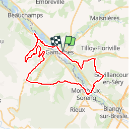
Trail Mountain bike of 32 km to be discovered at Hauts-de-France, Somme, Gamaches. This trail is proposed by tracegps.

Description

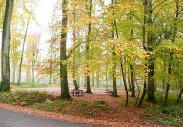
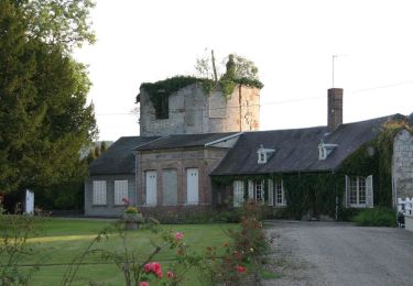
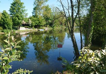
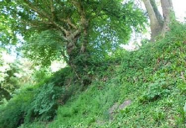
Au départ du parking de la mairie de Gamaches, partez vers la forêt de Bouillancourt en Serry via le GRP.Puis avoir traversé le domaine du château d'Ansennes vous repartirez sur l'autre rive de la Bresle vers la forêt domaniale de Eu pour rejoindre à nouveau la vallée. De là, vous suivrez les sentiers des étangs de Gamaches jusqu'au point de départ de cette sortie relativement "boisée" au dénivelé non négligeable.

Elevation profile

Positioning

Country:
France
Region :
Hauts-de-France
Department/Province :
Somme
Municipality :
Gamaches
Location:
Unknown
Start:(UTM)
396821 ; 5538016 (31U) N.

Comments

Please log in to post a review or rate the element


ussel


Trails nearby

Trail Walking Incheville - Balade dans le Massif du Triage - Forêt d'Eu - Photo
Walking
tracegps

Walking

Medium
(3)
Incheville, Normandy, Seine-Maritime, France
13.2 km | 16.8 km-effort
2h 45min
Yes
Trail On foot Gamaches - L'eau vive - Photo
On foot
PRO

On foot

Easy
Gamaches, Hauts-de-France, Somme, France
4.8 km | 5.3 km-effort
1h 11min
Yes
Trail On foot Gamaches - Au fil des Étangs - Photo
On foot
PRO

On foot

Easy
Gamaches, Hauts-de-France, Somme, France
3.1 km | 3.3 km-effort
45min
No
Trail Walking Incheville - incheville 20190513 les étangs  - Photo
Walking
philippe76

Walking

Very easy
(1)
Incheville, Normandy, Seine-Maritime, France
8.1 km | 9.3 km-effort
2h 6min
Yes
Trail Walking Bazinval - Circuit du Mont Madame (n° 4) - Bazinval - Photo
Walking
Brindille

Walking

Medium
Bazinval, Normandy, Seine-Maritime, France
12.4 km | 15.8 km-effort
3h 10min
Yes
Trail Walking Longroy - longroy - Photo
Walking
Brindille

Walking

Easy
Longroy, Normandy, Seine-Maritime, France
10.3 km | 12.7 km-effort
2h 38min
No
Trail Equestrian Monchaux-Soreng - Circuit du Mont Rôti (N° 16) - Monchaux-Soreng - Photo
Equestrian
tracegps

Equestrian

Medium
Monchaux-Soreng, Normandy, Seine-Maritime, France
10.4 km | 13.6 km-effort
1h 40min
Yes
Trail Mountain bike Monchaux-Soreng - Circuit du Mont Rôti (N° 16) - Monchaux-Soreng - Photo
Mountain bike
tracegps

Mountain bike

Easy
Monchaux-Soreng, Normandy, Seine-Maritime, France
10.4 km | 13.6 km-effort
45min
Yes
Trail Walking Monchaux-Soreng - Circuit du Mont Rôti (N° 16) - Monchaux-Soreng - Photo
Walking
tracegps

Walking

Medium
Monchaux-Soreng, Normandy, Seine-Maritime, France
10.4 km | 13.6 km-effort
2h 40min
Yes


Close
My subscriptions