


Mont Carpiagne depuis parc des Bruyères

motardes04
User
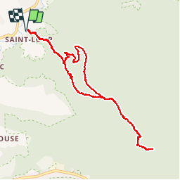

Length
10.4 km

Max alt
639 m

Uphill gradient
705 m
Km-Effort
19.8 km

Min alt
87 m

Downhill gradient
705 m
Boucle
Yes
Creation date :
2019-01-15 18:58:03.869
Updated on :
2019-01-15 18:58:03.869
4h13
Difficulty : Easy

FREE GPS app for hiking
 SityTrail
IGN / Geographical institutes
SityTrail Plus
The world is yours!
About
Trail Walking of 10.4 km to be discovered at Provence-Alpes-Côte d'Azur, Bouches-du-Rhône, Marseille. This trail is proposed by motardes04.
Description
20181118
Positioning
Country:
France
Region :
Provence-Alpes-Côte d'Azur
Department/Province :
Bouches-du-Rhône
Municipality :
Marseille
Location:
10th Arrondissement
Start:(Dec)
Start:(UTM)
697948 ; 4794198 (31T) N.
Comments