


coesmes

chasle
User
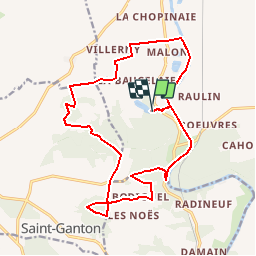

Length
18.3 km

Max alt
103 m

Uphill gradient
268 m
Km-Effort
22 km

Min alt
4 m

Downhill gradient
268 m
Boucle
Yes
Creation date :
2019-01-15 19:03:56.51
Updated on :
2019-11-21 09:08:11.479
--
Difficulty : Easy

FREE GPS app for hiking
 SityTrail
IGN / Geographical institutes
SityTrail Plus
The world is yours!
About
Trail Walking of 18.3 km to be discovered at Brittany, Ille-et-Vilaine, Guipry-Messac. This trail is proposed by chasle.
Positioning
Country:
France
Region :
Brittany
Department/Province :
Ille-et-Vilaine
Municipality :
Guipry-Messac
Location:
Guipry
Start:(Dec)
Start:(UTM)
585880 ; 5292694 (30T) N.
Comments