


rando Claudine ATPC 25 11 2018

pascha
User
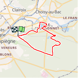

Length
12.2 km

Max alt
130 m

Uphill gradient
170 m
Km-Effort
14.5 km

Min alt
30 m

Downhill gradient
166 m
Boucle
Yes
Creation date :
2019-01-15 19:05:17.153
Updated on :
2019-01-15 19:05:17.153
3h07
Difficulty : Easy

FREE GPS app for hiking
 SityTrail
IGN / Geographical institutes
SityTrail Plus
The world is yours!
About
Trail Walking of 12.2 km to be discovered at Hauts-de-France, Oise, Compiègne. This trail is proposed by pascha.
Positioning
Country:
France
Region :
Hauts-de-France
Department/Province :
Oise
Municipality :
Compiègne
Location:
Unknown
Start:(Dec)
Start:(UTM)
488601 ; 5474361 (31U) N.
Comments