


Les collines autour du lac de Cécélès

grageot
User
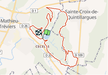

Length
13.5 km

Max alt
223 m

Uphill gradient
285 m
Km-Effort
17.3 km

Min alt
107 m

Downhill gradient
291 m
Boucle
Yes
Creation date :
2018-12-03 10:43:12.809
Updated on :
2018-12-03 10:43:12.809
4h15
Difficulty : Easy

FREE GPS app for hiking
 SityTrail
IGN / Geographical institutes
SityTrail Plus
The world is yours!
About
Trail Walking of 13.5 km to be discovered at Occitania, Hérault, Saint-Mathieu-de-Tréviers. This trail is proposed by grageot.
Description
nov 2018-Ballade facile avec de jolies vues sur le Pic St Loup.
L'AR vers le cote 199 n'est pas d'un grand intérêt
Positioning
Country:
France
Region :
Occitania
Department/Province :
Hérault
Municipality :
Saint-Mathieu-de-Tréviers
Location:
Unknown
Start:(Dec)
Start:(UTM)
571397 ; 4845913 (31T) N.
Comments