


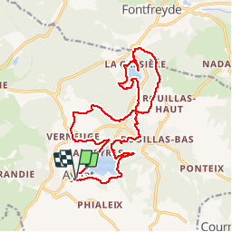
Le tour des lacs d'Aydat et La Cassière

tracegps
User

Length
19.2 km

Max alt
997 m

Uphill gradient
364 m
Km-Effort
24 km

Min alt
836 m

Downhill gradient
365 m
Boucle
Yes
Creation date :
2014-12-10 00:00:00.0
Updated on :
2014-12-10 00:00:00.0
5h00
Difficulty : Difficult

FREE GPS app for hiking
 SityTrail
IGN / Geographical institutes
SityTrail Plus
The world is yours!
About
Trail Walking of 19.2 km to be discovered at Auvergne-Rhône-Alpes, Puy-de-Dôme, Aydat. This trail is proposed by tracegps.
Description
Départ devant l'église Saint-Sidoine d'Aydat. Le circuit longe les lacs d'Aydat et de La Cassière, offre de nombreux points de vue sur la chaîne des puys et emprunte des chemins variés.
Photos


Positioning
Country:
France
Region :
Auvergne-Rhône-Alpes
Department/Province :
Puy-de-Dôme
Municipality :
Aydat
Location:
Unknown
Start:(Dec)
Start:(UTM)
498061 ; 5056260 (31T) N.
Comments
Pas mal