


RocherPrincesSR170319SR171219

fmg
User
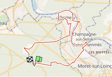

Length
21 km

Max alt
105 m

Uphill gradient
228 m
Km-Effort
24 km

Min alt
41 m

Downhill gradient
226 m
Boucle
Yes
Creation date :
2019-01-15 19:17:37.392
Updated on :
2019-12-17 19:00:20.129
6h15
Difficulty : Medium

FREE GPS app for hiking
 SityTrail
IGN / Geographical institutes
SityTrail Plus
The world is yours!
About
Trail Walking of 21 km to be discovered at Ile-de-France, Seine-et-Marne, Fontainebleau. This trail is proposed by fmg.
Description
forêt, bords de Seine, ancien vélodrome, murs à vigne inscrits M.H. Thomery, mare Episy.
Positioning
Country:
France
Region :
Ile-de-France
Department/Province :
Seine-et-Marne
Municipality :
Fontainebleau
Location:
Unknown
Start:(Dec)
Start:(UTM)
481437 ; 5357777 (31U) N.
Comments