


les chemins de Telgruc

cron
User
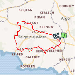

Length
13.2 km

Max alt
111 m

Uphill gradient
221 m
Km-Effort
16.1 km

Min alt
27 m

Downhill gradient
221 m
Boucle
Yes
Creation date :
2019-01-15 19:29:07.543
Updated on :
2019-01-15 19:29:07.543
3h45
Difficulty : Easy

FREE GPS app for hiking
 SityTrail
IGN / Geographical institutes
SityTrail Plus
The world is yours!
About
Trail Walking of 13.2 km to be discovered at Brittany, Finistère, Telgruc-sur-Mer. This trail is proposed by cron.
Positioning
Country:
France
Region :
Brittany
Department/Province :
Finistère
Municipality :
Telgruc-sur-Mer
Location:
Unknown
Start:(Dec)
Start:(UTM)
401651 ; 5342423 (30U) N.
Comments
belle balade