


Guisay Caf 2018 12 05

psesjs
User
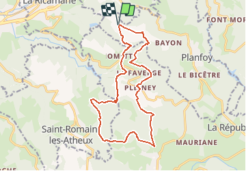

Length
17.3 km

Max alt
1070 m

Uphill gradient
536 m
Km-Effort
24 km

Min alt
814 m

Downhill gradient
538 m
Boucle
Yes
Creation date :
2019-01-15 19:30:37.046
Updated on :
2020-05-20 12:05:14.527
5h08
Difficulty : Unknown

FREE GPS app for hiking
 SityTrail
IGN / Geographical institutes
SityTrail Plus
The world is yours!
About
Trail Walking of 17.3 km to be discovered at Auvergne-Rhône-Alpes, Loire, Planfoy. This trail is proposed by psesjs.
Positioning
Country:
France
Region :
Auvergne-Rhône-Alpes
Department/Province :
Loire
Municipality :
Planfoy
Location:
Unknown
Start:(Dec)
Start:(UTM)
609681 ; 5027786 (31T) N.
Comments