


Le colorado provencale de Rustrel

pat844
User
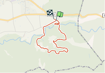

Length
3.6 km

Max alt
433 m

Uphill gradient
83 m
Km-Effort
4.7 km

Min alt
353 m

Downhill gradient
81 m
Boucle
Yes
Creation date :
2019-01-15 19:31:22.65
Updated on :
2019-01-15 19:31:22.65
1h29
Difficulty : Unknown

FREE GPS app for hiking
 SityTrail
IGN / Geographical institutes
SityTrail Plus
The world is yours!
About
Trail Walking of 3.6 km to be discovered at Provence-Alpes-Côte d'Azur, Vaucluse, Rustrel. This trail is proposed by pat844.
Positioning
Country:
France
Region :
Provence-Alpes-Côte d'Azur
Department/Province :
Vaucluse
Municipality :
Rustrel
Location:
Unknown
Start:(Dec)
Start:(UTM)
700750 ; 4865905 (31T) N.
Comments