


Bec de Jus

ajd26
User

Length
14.5 km

Max alt
1153 m

Uphill gradient
826 m
Km-Effort
25 km

Min alt
558 m

Downhill gradient
825 m
Boucle
Yes
Creation date :
2019-05-19 18:03:13.086
Updated on :
2019-05-19 18:03:13.186
4h48
Difficulty : Medium

FREE GPS app for hiking
 SityTrail
IGN / Geographical institutes
SityTrail Plus
The world is yours!
About
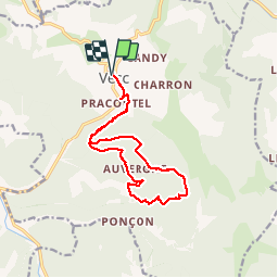
Trail Walking of 14.5 km to be discovered at Auvergne-Rhône-Alpes, Drôme, Vesc. This trail is proposed by ajd26.
Description
Départ de Vesc, montée au Bec de Jus avec une trace, la descente se fait au gps jusqu'à retrouver une trace de chemin
Positioning
Country:
France
Region :
Auvergne-Rhône-Alpes
Department/Province :
Drôme
Municipality :
Vesc
Location:
Unknown
Start:(Dec)
Start:(UTM)
670970 ; 4932143 (31T) N.
Comments