


Pas de l'Ase

ARVIEU
User
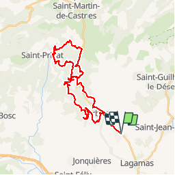

Length
36 km

Max alt
712 m

Uphill gradient
1126 m
Km-Effort
51 km

Min alt
150 m

Downhill gradient
1127 m
Boucle
Yes
Creation date :
2019-01-15 19:43:25.09
Updated on :
2019-01-15 19:43:25.09
3h30
Difficulty : Medium

FREE GPS app for hiking
 SityTrail
IGN / Geographical institutes
SityTrail Plus
The world is yours!
About
Trail Mountain bike of 36 km to be discovered at Occitania, Hérault, Montpeyroux. This trail is proposed by ARVIEU.
Description
Montpeyroux Les Salces le Pas de l'Ase le col du Vent le Roc Traucat Arboras Montpeyroux
Positioning
Country:
France
Region :
Occitania
Department/Province :
Hérault
Municipality :
Montpeyroux
Location:
Unknown
Start:(Dec)
Start:(UTM)
540727 ; 4838177 (31T) N.
Comments