Trail Walking Harly - Le grand Culot - Photo
 tracegps
tracegps

User

© OpenStreetMap contributors
Length
Length
10 km
Max alt
Max alt
111 m
Uphill gradient
Uphill gradient
107 m
Km-Effort
Km-Effort  
11.4 km
Min alt
Min alt
72 m
Downhill gradient
Downhill gradient
107 m
Boucle
Boucle
Yes
Creation date :
2014-12-10 00:00:00.0
Updated on :
2014-12-10 00:00:00.0

(0 Reviews)

Walking
Walking
2h30
Difficulty : Medium

Scan this QR Code to open this trail in the SityTrail application

FREE GPS app for hiking

Logo SityTrail SityTrail

IGN / Geographical institutes

Download SityTrail from the App Store Download SityTrail from Google Play

Logo SityTrail SityTrail World

The world is yours!

Download SityTrail from the App Store Download SityTrail from Google Play Download SityTrail on Huawei AppGallery

About

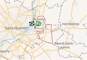
Trail Walking of 10 km to be discovered at Hauts-de-France, Aisne, Harly. This trail is proposed by tracegps.

Description

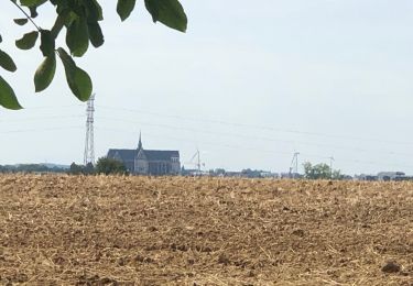
De l'autre côté de la Somme, la basilique de Saint-Quentin joue les sentinelles. Encore une promenade périurbaine aisée (nombreuses portions bitumées), qui longe un temps la réserve naturelle d'Isle puis traverse la vallée de l'Homblières. Toutes les infos sont ICI

Elevation profile

Photos

Positioning

Country:
France
Region :
Hauts-de-France
Department/Province :
Aisne
Municipality :
Harly
Location:
Unknown
Start:(UTM)
522612 ; 5521504 (31U) N.

Trails nearby

Trail Mountain bike Mesnil-Saint-Laurent - mesnil-fresnoy le grand-montbrehain -lesdits  - Photo
Mountain bike
alainwald

Mountain bike

Easy
Mesnil-Saint-Laurent, Hauts-de-France, Aisne, France
55 km | 62 km-effort
4h 35min
Yes
Trail Mountain bike Mesnil-Saint-Laurent - parcours mesnil thenelles- beautor- Mennessis  - Photo
Mountain bike
alainwald

Mountain bike

Very easy
Mesnil-Saint-Laurent, Hauts-de-France, Aisne, France
63 km | 69 km-effort
3h 21min
Yes
Trail Walking Rouvroy - circuit rouvroy fonsomme croix fonsommes - Photo
Walking
alainwald

Walking

Easy
Rouvroy, Hauts-de-France, Aisne, France
24 km | 27 km-effort
4h 33min
Yes
Trail Walking Homblières - homblières  Fonsomme  - Photo
Walking
alainwald

Walking

Easy
Homblières, Hauts-de-France, Aisne, France
21 km | 24 km-effort
4h 13min
Yes
Trail Walking Saint-Quentin - Le marais d'Isle - Photo
Walking

Walking

Very easy
Saint-Quentin, Hauts-de-France, Aisne, France
5.4 km | 6 km-effort
Unknown
Yes
Trail Mountain bike Mesnil-Saint-Laurent - mesnil - Vendeuil  - Photo
Mountain bike
alainwald

Mountain bike

Easy
Mesnil-Saint-Laurent, Hauts-de-France, Aisne, France
46 km | 49 km-effort
4h 1min
Yes
Trail Walking Fayet - Les éoliennes le Tronquoi - Photo
Walking
ggguerin

Walking

Medium
Fayet, Hauts-de-France, Aisne, France
9.5 km | 10.9 km-effort
2h 4min
Yes
Trail Walking Saint-Quentin - Parc d'isle - Photo
Walking
JJDOLLE

Walking

Very easy
Saint-Quentin, Hauts-de-France, Aisne, France
5.9 km | 6.5 km-effort
1h 40min
Yes
Trail Walking Saint-Quentin - Du canal au chemin de fer - Saint-Quentin - Photo
Walking
tracegps

Walking

Medium
Saint-Quentin, Hauts-de-France, Aisne, France
7.2 km | 8.3 km-effort
2h 0min
Yes


Close
My subscriptions