


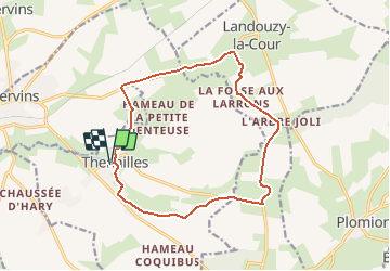
La verte-vallée - Thenailles

tracegps
User


3h30
Difficulty : Medium

FREE GPS app for hiking
 SityTrail
IGN / Geographical institutes
SityTrail Plus
The world is yours!
About
Trail Walking of 13.8 km to be discovered at Hauts-de-France, Aisne, Thenailles. This trail is proposed by tracegps.
Description
Au XIIe siècle, alors que saint Norbert venait de fonder l'ordre des Prémontrés en forêt de Saint-Gobain, l'évêque de Laon fit construire une abbaye de cet ordre naissant à Thenailles. A cette époque, la région était, comme une grande partie de la Thiérache, couverte de bois, ce que bien des noms de lieux-dits rappellent aujourd'hui. Toutes les infos sont ICI
Photos

Positioning
Comments