


MONTFORT. Voie Royale ;Vieux chateau nvsd . o

RobinMicheline
User GUIDE
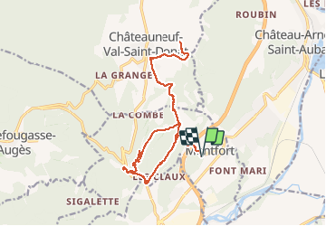

Length
21 km

Max alt
640 m

Uphill gradient
473 m
Km-Effort
27 km

Min alt
438 m

Downhill gradient
475 m
Boucle
Yes
Creation date :
2019-05-16 07:40:07.849
Updated on :
2020-01-22 19:14:19.195
5h49
Difficulty : Medium

FREE GPS app for hiking
 SityTrail
IGN / Geographical institutes
SityTrail Plus
The world is yours!
About
Trail Walking of 21 km to be discovered at Provence-Alpes-Côte d'Azur, Alpes-de-Haute-Provence, Montfort. This trail is proposed by RobinMicheline.
Description
Voie Royale .Vieux Chateau NVSD
Positioning
Country:
France
Region :
Provence-Alpes-Côte d'Azur
Department/Province :
Alpes-de-Haute-Provence
Municipality :
Montfort
Location:
Unknown
Start:(Dec)
Start:(UTM)
737899 ; 4883047 (31T) N.
Comments