


Le Thoronet

aljac
User
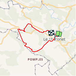

Length
12 km

Max alt
314 m

Uphill gradient
326 m
Km-Effort
16.4 km

Min alt
137 m

Downhill gradient
327 m
Boucle
Yes
Creation date :
2019-01-15 19:48:34.243
Updated on :
2019-01-15 19:48:34.243
3h08
Difficulty : Unknown

FREE GPS app for hiking
 SityTrail
IGN / Geographical institutes
SityTrail Plus
The world is yours!
About
Trail Other activity of 12 km to be discovered at Provence-Alpes-Côte d'Azur, Var, Le Thoronet. This trail is proposed by aljac.
Positioning
Country:
France
Region :
Provence-Alpes-Côte d'Azur
Department/Province :
Var
Municipality :
Le Thoronet
Location:
Unknown
Start:(Dec)
Start:(UTM)
281779 ; 4814454 (32T) N.
Comments