


Montée Chabanals par vallon Demandolx

GrouGary
User
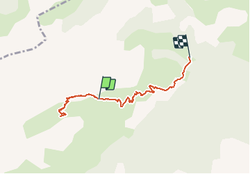

Length
6.2 km

Max alt
2071 m

Uphill gradient
207 m
Km-Effort
10.8 km

Min alt
1324 m

Downhill gradient
754 m
Boucle
No
Creation date :
2019-01-15 19:55:06.976
Updated on :
2019-01-15 19:55:06.976
3h59
Difficulty : Medium

FREE GPS app for hiking
 SityTrail
IGN / Geographical institutes
SityTrail Plus
The world is yours!
About
Trail Snowshoes of 6.2 km to be discovered at Provence-Alpes-Côte d'Azur, Maritime Alps, Saint-Étienne-de-Tinée. This trail is proposed by GrouGary.
Description
A/R pour finir en raquettes sur la crête, face aux Pistes Auron
(géolocalisation non faite au départ)
Positioning
Country:
France
Region :
Provence-Alpes-Côte d'Azur
Department/Province :
Maritime Alps
Municipality :
Saint-Étienne-de-Tinée
Location:
Unknown
Start:(Dec)
Start:(UTM)
330585 ; 4901849 (32T) N.
Comments