


2019 07 Chablais J4

staubalex
User
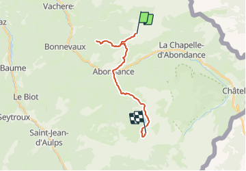

Length
17.7 km

Max alt
1805 m

Uphill gradient
1026 m
Km-Effort
31 km

Min alt
924 m

Downhill gradient
1033 m
Boucle
No
Creation date :
2019-01-15 19:57:50.251
Updated on :
2019-01-15 19:57:50.251
6h21
Difficulty : Difficult

FREE GPS app for hiking
 SityTrail
IGN / Geographical institutes
SityTrail Plus
The world is yours!
About
Trail Walking of 17.7 km to be discovered at Auvergne-Rhône-Alpes, Upper Savoy, Vacheresse. This trail is proposed by staubalex.
Positioning
Country:
France
Region :
Auvergne-Rhône-Alpes
Department/Province :
Upper Savoy
Municipality :
Vacheresse
Location:
Unknown
Start:(Dec)
Start:(UTM)
326231 ; 5130638 (32T) N.
Comments