Trail Walking Moyenneville - Le rideau Favery - Moyenneville - Photo

Le rideau Favery - Moyenneville

 tracegps
tracegps

User

© OpenStreetMap contributors
Length
Length
13.9 km
Max alt
Max alt
90 m
Uphill gradient
Uphill gradient
192 m
Km-Effort
Km-Effort  
16.4 km
Min alt
Min alt
23 m
Downhill gradient
Downhill gradient
192 m
Boucle
Boucle
Yes
Creation date :
2014-12-10 00:00:00.0
Updated on :
2014-12-10 00:00:00.0

(1 Reviews)

Walking
Walking
4h30
Difficulty : Very difficult

Scan this QR Code to open this trail in the SityTrail application

FREE GPS app for hiking

Logo SityTrail SityTrail

IGN / Geographical institutes

Download SityTrail from the App Store Download SityTrail from Google Play

Logo SityTrail SityTrail World

The world is yours!

Download SityTrail from the App Store Download SityTrail from Google Play Download SityTrail on Huawei AppGallery

About

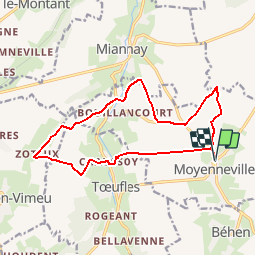
Trail Walking of 13.9 km to be discovered at Hauts-de-France, Somme, Moyenneville. This trail is proposed by tracegps.

Description

Si le patrimoine de Moyenneville a souffert lors de la dernière guerre, la campagne environnante dans la vallée de la Trie ne demande qu’à vous accueillir. Pour télécharger la fiche du circuit en format pdf. Partez à la découverte de la Côte Picarde et de la Baie de Somme à travers 38 promenades et randonnées pédestres.

Elevation profile

Photos

Positioning

Country:
France
Region :
Hauts-de-France
Department/Province :
Somme
Municipality :
Moyenneville
Location:
Unknown
Start:(UTM)
410549 ; 5547462 (31U) N.

Comments

Please log in to post a review or rate the element


Trails nearby

Trail Walking Miannay - Les Auteux - Miannay - Photo
Walking
tracegps

Walking

Medium
(2)
Miannay, Hauts-de-France, Somme, France
7.6 km | 9.3 km-effort
2h 19min
Yes
Trail Walking Yonval - Les 3 Fétus - Yonval - Photo
Walking
tracegps

Walking

Difficult
(2)
Yonval, Hauts-de-France, Somme, France
7.5 km | 9.4 km-effort
2h 30min
Yes
Trail Road bike Béhen - Béhen Huppy Boëncourt - Photo
Road bike
Michel Tondus

Road bike

Easy
Béhen, Hauts-de-France, Somme, France
11.9 km | 12.8 km-effort
59min
Yes
Trail Running Béhen - Les Alleux - Photo
Running
Michel Tondus

Running

Béhen, Hauts-de-France, Somme, France
8.3 km | 8.8 km-effort
55min
Yes
Trail On foot Mareuil-Caubert - La Vallée de Frosme - Photo
On foot
PRO

On foot

Easy
Mareuil-Caubert, Hauts-de-France, Somme, France
9.1 km | 11.5 km-effort
2h 37min
Yes
Trail On foot Béhen - Vallée de Bienfay - Photo
On foot
PRO

On foot

Easy
Béhen, Hauts-de-France, Somme, France
10.5 km | 11.7 km-effort
2h 39min
Yes
Trail On foot Tœufles - Circuit de Toeufles - Photo
On foot
PRO

On foot

Easy
Tœufles, Hauts-de-France, Somme, France
13.7 km | 16 km-effort
3h 37min
Yes
Trail Walking Huchenneville - Circuit d'Inval - Hucheneville - Photo
Walking
tracegps

Walking

Difficult
Huchenneville, Hauts-de-France, Somme, France
9.8 km | 12.8 km-effort
3h 0min
Yes
Trail Walking Moyenneville - La Vallée de Bienfay - Photo
Walking
tracegps

Walking

Difficult
Moyenneville, Hauts-de-France, Somme, France
10.4 km | 11.7 km-effort
3h 10min
Yes


Close
My subscriptions