


J6 LURE

ophness
User
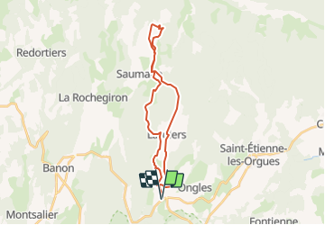

Length
27 km

Max alt
1100 m

Uphill gradient
672 m
Km-Effort
36 km

Min alt
624 m

Downhill gradient
672 m
Boucle
Yes
Creation date :
2019-01-15 19:58:31.974
Updated on :
2019-01-15 19:58:31.974
--
Difficulty : Unknown

FREE GPS app for hiking
 SityTrail
IGN / Geographical institutes
SityTrail Plus
The world is yours!
About
Trail Equestrian of 27 km to be discovered at Provence-Alpes-Côte d'Azur, Alpes-de-Haute-Provence, Ongles. This trail is proposed by ophness.
Positioning
Country:
France
Region :
Provence-Alpes-Côte d'Azur
Department/Province :
Alpes-de-Haute-Provence
Municipality :
Ongles
Location:
Unknown
Start:(Dec)
Start:(UTM)
717089 ; 4877745 (31T) N.
Comments