


04 TREVANS PONT TUF_backup

Nathy8913
User
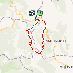

Length
11.8 km

Max alt
1019 m

Uphill gradient
540 m
Km-Effort
19 km

Min alt
749 m

Downhill gradient
540 m
Boucle
Yes
Creation date :
2019-01-15 20:02:06.027
Updated on :
2019-01-15 20:02:06.027
3h54
Difficulty : Difficult

FREE GPS app for hiking
 SityTrail
IGN / Geographical institutes
SityTrail Plus
The world is yours!
About
Trail Walking of 11.8 km to be discovered at Provence-Alpes-Côte d'Azur, Alpes-de-Haute-Provence, Beynes. This trail is proposed by Nathy8913.
Points of interest


Positioning
Country:
France
Region :
Provence-Alpes-Côte d'Azur
Department/Province :
Alpes-de-Haute-Provence
Municipality :
Beynes
Location:
Unknown
Start:(Dec)
Start:(UTM)
279394 ; 4870494 (32T) N.
Comments