


Axe vert de Thiérache 2

tracegps
User
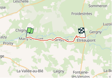

Length
10.9 km

Max alt
145 m

Uphill gradient
85 m
Km-Effort
11.9 km

Min alt
111 m

Downhill gradient
65 m
Boucle
No
Creation date :
2014-12-10 00:00:00.0
Updated on :
2014-12-10 00:00:00.0
3h00
Difficulty : Medium

FREE GPS app for hiking
 SityTrail
IGN / Geographical institutes
SityTrail Plus
The world is yours!
About
Trail Walking of 10.9 km to be discovered at Hauts-de-France, Aisne, Marly-Gomont. This trail is proposed by tracegps.
Description
La deuxième étape de cette sortie week-end. Toutes les infos sont ICI
Photos

Positioning
Country:
France
Region :
Hauts-de-France
Department/Province :
Aisne
Municipality :
Marly-Gomont
Location:
Unknown
Start:(Dec)
Start:(UTM)
556092 ; 5528524 (31U) N.
Comments