Trail Running Chamonix-Mont-Blanc - The North Face© Ultra Trail du Mont-Blanc© UTMB 2008 - Photo

The North Face© Ultra Trail du Mont-Blanc© UTMB 2008

 tracegps
tracegps

User

© OpenStreetMap contributors
Length
Length
160 km
Max alt
Max alt
2537 m
Uphill gradient
Uphill gradient
9586 m
Km-Effort
Km-Effort  
288 km
Min alt
Min alt
806 m
Downhill gradient
Downhill gradient
9587 m
Boucle
Boucle
Yes
Creation date :
2014-12-10 00:00:00.0
Updated on :
2014-12-10 00:00:00.0

(2 Reviews)

Running
Running
46h00
Difficulty : Very difficult

Scan this QR Code to open this trail in the SityTrail application

FREE GPS app for hiking

Logo SityTrail SityTrail

IGN / Geographical institutes

Download SityTrail from the App Store Download SityTrail from Google Play

Logo SityTrail SityTrail World

The world is yours!

Download SityTrail from the App Store Download SityTrail from Google Play Download SityTrail on Huawei AppGallery

About

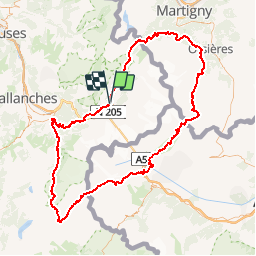
Trail Running of 160 km to be discovered at Auvergne-Rhône-Alpes, Upper Savoy, Chamonix-Mont-Blanc. This trail is proposed by tracegps.

Description

The North Face® Ultra-Trail® Tour du Mont-Blanc édition 2008. Les Trailers du Mont Blanc et les communes françaises, italiennes et suisses du Pays du Mont-Blanc vous invitent à partager une aventure extraordinaire, parcourir le tour du Mont-Blanc en individuel en une seule étape en traversant 3 pays ! 29-31 août 2008 L’UTMB, c’est environ 163 km et 9400 m de dénivelé positif - 46 heures maxi . Une formidable épopée d'ultra dans un environnement magique. Cette épreuve est l'aboutissement d'un rêve de longue date et d'une passion pour l'Ultra-Trail, partagés par un nombre de plus en plus grand de coureurs et d'accompagnateurs des trois pays. Sa concrétisation n'est possible que grâce à l'amitié qui lie les habitants des communes françaises, italiennes et suisses du pays du Mont-Blanc. Le parcours de The North Face® Ultra-Trail® Tour du Mont-Blanc emprunte en grande partie le sentier international de Grande Randonnée du Tour du Mont-Blanc (GR TMB). Retrouvez l’ensemble des informations indispensables avant et après l’évènement sur le site de l’UTMB, The North Face® Ultra-Trail® Tour du Mont-Blanc !!

Elevation profile

Photos

Positioning

Country:
France
Region :
Auvergne-Rhône-Alpes
Department/Province :
Upper Savoy
Municipality :
Chamonix-Mont-Blanc
Location:
Unknown
Start:(UTM)
334747 ; 5087781 (32T) N.

Comments

Please log in to post a review or rate the element


perte de la réception GPS frequente


Trails nearby

Trail Walking Chamonix-Mont-Blanc - Circuit de la Mer de Glace - Chamonix Mont Blanc - Photo
Walking
tracegps

Walking

Difficult
(2)
Chamonix-Mont-Blanc, Auvergne-Rhône-Alpes, Upper Savoy, France
13.3 km | 24 km-effort
5h 30min
Yes
Trail Walking Chamonix-Mont-Blanc - Glacier des Bossons Les Houches Chamonix - Photo
Walking
tracegps

Walking

Difficult
(2)
Chamonix-Mont-Blanc, Auvergne-Rhône-Alpes, Upper Savoy, France
13.1 km | 28 km-effort
5h 0min
Yes
Trail Running Chamonix-Mont-Blanc - Hôtel Arveyron au Chalet de la Floria - Photo
Running
Albust

Running

Medium
(1)
Chamonix-Mont-Blanc, Auvergne-Rhône-Alpes, Upper Savoy, France
10.4 km | 15.5 km-effort
1h 28min
Yes
Trail Walking Chamonix-Mont-Blanc - La cascade du dard - Photo
Walking
GUIDE
pascalou73

Walking

Medium
Chamonix-Mont-Blanc, Auvergne-Rhône-Alpes, Upper Savoy, France
8.2 km | 13.6 km-effort
2h 0min
Yes
Trail Walking Chamonix-Mont-Blanc - Le lac bleus - Photo
Walking
GUIDE
pascalou73

Walking

Medium
Chamonix-Mont-Blanc, Auvergne-Rhône-Alpes, Upper Savoy, France
17.1 km | 35 km-effort
6h 57min
Yes
Trail Mountain bike Chamonix-Mont-Blanc - vtt à Chamonix - Photo
Mountain bike
GUIDE
pascalou73

Mountain bike

Medium
Chamonix-Mont-Blanc, Auvergne-Rhône-Alpes, Upper Savoy, France
15.9 km | 19.5 km-effort
1h 30min
No
Trail Other activity Chamonix-Mont-Blanc - vallée blanche - Photo
Other activity
jnpollet

Other activity

Difficult
(1)
Chamonix-Mont-Blanc, Auvergne-Rhône-Alpes, Upper Savoy, France
19.8 km | 30 km-effort
3h 21min
No
Trail Walking Chamonix-Mont-Blanc - aller/retour La Floria Chamonix  - Photo
Walking
jeff2

Walking

Easy
Chamonix-Mont-Blanc, Auvergne-Rhône-Alpes, Upper Savoy, France
5.6 km | 9.9 km-effort
1h 22min
Yes
Trail Walking Les Houches - boucle aiguillette des houches ,refuge bel-lachat - Photo
Walking
carton-fils@orange.fr

Walking

Very difficult
Les Houches, Auvergne-Rhône-Alpes, Upper Savoy, France
10.4 km | 24 km-effort
2h 49min
Yes


Close
My subscriptions