


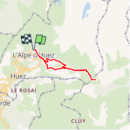
route sare`nne 3-2-19

pe78
User

Length
9.5 km

Max alt
1876 m

Uphill gradient
237 m
Km-Effort
12.6 km

Min alt
1767 m

Downhill gradient
234 m
Boucle
Yes
Creation date :
2019-01-15 20:23:47.62
Updated on :
2019-01-15 20:23:47.62
2h10
Difficulty : Very easy

FREE GPS app for hiking
 SityTrail
IGN / Geographical institutes
SityTrail Plus
The world is yours!
About
Trail Walking of 9.5 km to be discovered at Auvergne-Rhône-Alpes, Isère, Huez. This trail is proposed by pe78.
Positioning
Country:
France
Region :
Auvergne-Rhône-Alpes
Department/Province :
Isère
Municipality :
Huez
Location:
Unknown
Start:(Dec)
Start:(UTM)
269478 ; 4997580 (32T) N.
Comments