


calvison sommiere

mthomas30
User
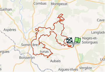

Length
62 km

Max alt
181 m

Uphill gradient
1029 m
Km-Effort
76 km

Min alt
35 m

Downhill gradient
1029 m
Boucle
Yes
Creation date :
2019-01-15 20:26:35.588
Updated on :
2019-01-15 20:26:35.588
6h08
Difficulty : Difficult

FREE GPS app for hiking
 SityTrail
IGN / Geographical institutes
SityTrail Plus
The world is yours!
About
Trail Mountain bike of 62 km to be discovered at Occitania, Gard, Calvisson. This trail is proposed by mthomas30.
Description
monotrace a gogo
Positioning
Country:
France
Region :
Occitania
Department/Province :
Gard
Municipality :
Calvisson
Location:
Unknown
Start:(Dec)
Start:(UTM)
595924 ; 4848084 (31T) N.
Comments