


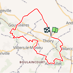
ADAL_Thoiry_28112017

micheldelaramdo
User

Length
18 km

Max alt
182 m

Uphill gradient
234 m
Km-Effort
21 km

Min alt
117 m

Downhill gradient
234 m
Boucle
Yes
Creation date :
2019-01-15 20:29:26.023
Updated on :
2019-01-15 20:29:26.023
4h36
Difficulty : Medium

FREE GPS app for hiking
 SityTrail
IGN / Geographical institutes
SityTrail Plus
The world is yours!
About
Trail Walking of 18 km to be discovered at Ile-de-France, Yvelines, Thoiry. This trail is proposed by micheldelaramdo.
Positioning
Country:
France
Region :
Ile-de-France
Department/Province :
Yvelines
Municipality :
Thoiry
Location:
Unknown
Start:(Dec)
Start:(UTM)
412017 ; 5413636 (31U) N.
Comments