


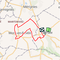
Des basses terres aux hauteurs de Pévèle (Bersée)

tracegps
User


2h49
Difficulty : Medium

FREE GPS app for hiking
 SityTrail
IGN / Geographical institutes
SityTrail Plus
The world is yours!
About
Trail Walking of 11.2 km to be discovered at Hauts-de-France, Nord, Bersée. This trail is proposed by tracegps.
Description
Départ de la mairie de Bersée. Passant par les basses terres de la plaine de Bersée (43m) cette randonnée vous conduit aux hauteurs du Mont de Pévèle (90m). Retrouvez cette randonnée sur le site de la Communauté de Communes du Pays de Pévèle.
Photos
 - Photo 1")
 - Photo 2")
 - Photo 3")
 - Photo 4")
 - Photo 5")
 - Photo 6")
Positioning
Comments