


chatillon sur cher

mimilolo
User
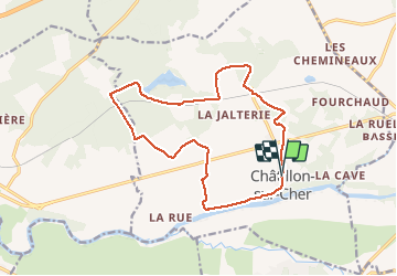

Length
15.1 km

Max alt
119 m

Uphill gradient
166 m
Km-Effort
17.3 km

Min alt
75 m

Downhill gradient
167 m
Boucle
Yes
Creation date :
2019-03-31 15:50:42.411
Updated on :
2019-03-31 15:50:42.411
2h27
Difficulty : Unknown

FREE GPS app for hiking
 SityTrail
IGN / Geographical institutes
SityTrail Plus
The world is yours!
About
Trail Other activity of 15.1 km to be discovered at Centre-Loire Valley, Loir-et-Cher, Châtillon-sur-Cher. This trail is proposed by mimilolo.
Description
club des laurends
Positioning
Country:
France
Region :
Centre-Loire Valley
Department/Province :
Loir-et-Cher
Municipality :
Châtillon-sur-Cher
Location:
Unknown
Start:(Dec)
Start:(UTM)
386093 ; 5236936 (31T) N.
Comments