


la dent de Moirans

jphugon
User
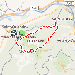

Length
11.9 km

Max alt
990 m

Uphill gradient
616 m
Km-Effort
20 km

Min alt
451 m

Downhill gradient
613 m
Boucle
Yes
Creation date :
2019-01-15 20:34:27.234
Updated on :
2019-01-15 20:34:27.234
4h06
Difficulty : Medium

FREE GPS app for hiking
 SityTrail
IGN / Geographical institutes
SityTrail Plus
The world is yours!
About
Trail Walking of 11.9 km to be discovered at Auvergne-Rhône-Alpes, Isère, Montaud. This trail is proposed by jphugon.
Positioning
Country:
France
Region :
Auvergne-Rhône-Alpes
Department/Province :
Isère
Municipality :
Montaud
Location:
Unknown
Start:(Dec)
Start:(UTM)
700130 ; 5016432 (31T) N.
Comments