


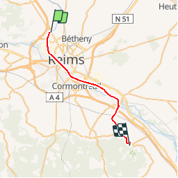

18.1 km | 21 km-effort

User


FREE GPS app for hiking
 SityTrail
IGN / Geographical institutes
SityTrail World
The world is yours!
Trail Walking of 25 km to be discovered at Grand Est, Marne, Reims. This trail is proposed by tracegps.
Le Chemin de Compostelle, voie de Vézelay GR654® présenté par le Comité Régional du Tourisme de Champagne-Ardenne. Chemin de Compostelle, Voie de Vézelay GR654® De Reims à Verzy. Septième étape. Au départ du Reims, le chemin part à l’assaut du versant Nord de la Montagne de Reims et son prestigieux vignoble, en rejoignant notamment Verzenay. Vous trouverez le descriptif détaillé de cette randonnée dans le Topo-guide® de la Fédération Française de la Randonnée Pédestre.


Walking

Running

Hybrid bike

Cycle


sport

Walking

On foot
On foot

Mountain bike
Pratique