Trail Walking Châlons-en-Champagne - Chemin de Compostelle, Voie de Vézelay GR654® De Châlons en Champagne à La Chaussée sur Marne - Photo

Chemin de Compostelle, Voie de Vézelay GR654® De Châlons en Champagne à La Chaussée sur Marne

 tracegps
tracegps

User

© OpenStreetMap contributors
Length
Length
24 km
Max alt
Max alt
96 m
Uphill gradient
Uphill gradient
124 m
Km-Effort
Km-Effort  
26 km
Min alt
Min alt
78 m
Downhill gradient
Downhill gradient
109 m
Boucle
Boucle
No
Creation date :
2014-12-10 00:00:00.0
Updated on :
2014-12-10 00:00:00.0

(0 Reviews)

Walking
Walking
4h49
Difficulty : Difficult

Scan this QR Code to open this trail in the SityTrail application

FREE GPS app for hiking

Logo SityTrail SityTrail

IGN / Geographical institutes

Download SityTrail from the App Store Download SityTrail from Google Play

Logo SityTrail SityTrail World

The world is yours!

Download SityTrail from the App Store Download SityTrail from Google Play Download SityTrail on Huawei AppGallery

About

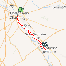
Trail Walking of 24 km to be discovered at Grand Est, Marne, Châlons-en-Champagne. This trail is proposed by tracegps.

Description

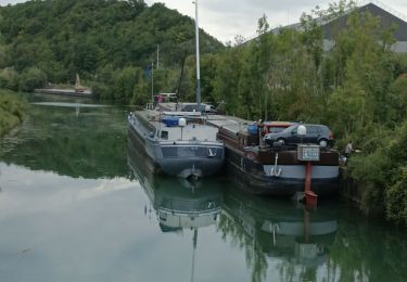
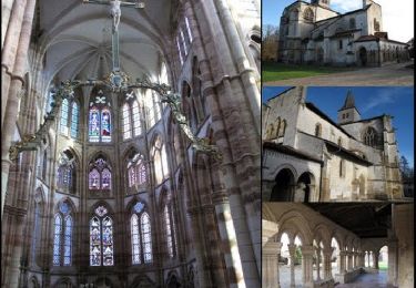
Le Chemin de Compostelle, voie de Vézelay GR654® présenté par le Comité Régional du Tourisme de Champagne-Ardenne. Chemin de Compostelle, Voie de Vézelay GR654® De Châlons en Champagne à La Chaussée sur Marne. Dixième étape. Cette étape traverse la plaine champenoise en suivant la vallée de la Marne et ses nombreuses gravières. Le chemin longe le chemin de halage du canal latéral à la Marne. Vous trouverez le descriptif détaillé de cette randonnée dans le Topo-guide® de la Fédération Française de la Randonnée Pédestre.

Elevation profile

Photos

Positioning

Country:
France
Region :
Grand Est
Department/Province :
Marne
Municipality :
Châlons-en-Champagne
Location:
Unknown
Start:(UTM)
598997 ; 5423273 (31U) N.

Trails nearby

Trail Mountain bike Châlons-en-Champagne - Vallée et Champagne crayeuse - Photo
Mountain bike
tracegps

Mountain bike

Medium
(1)
Châlons-en-Champagne, Grand Est, Marne, France
35 km | 38 km-effort
2h 30min
Yes
Trail Electric bike Châlons-en-Champagne - Chalons en Champagne Vitry le François  - Photo
Electric bike
FPortier

Electric bike

Very easy
Châlons-en-Champagne, Grand Est, Marne, France
32 km | 34 km-effort
3h 25min
No
Trail Walking Châlons-en-Champagne - La Via Francigena - Châlons en Champagne- Vitry le François - Photo
Walking
tracegps

Walking

Medium
Châlons-en-Champagne, Grand Est, Marne, France
45 km | 49 km-effort
10h 0min
No
Trail Nordic walking Châlons-en-Champagne - Châlons en Champagnbe 10 620m +54m - Photo
Nordic walking
DanielROLLET

Nordic walking

Easy
Châlons-en-Champagne, Grand Est, Marne, France
10.6 km | 11.3 km-effort
2h 20min
Yes
Trail Bicycle tourism Châlons-en-Champagne - Chalons - Sainte-Marie du Lac 62 km - Photo
Bicycle tourism
GUIDE
jeanmarcMasson

Bicycle tourism

Very difficult
Châlons-en-Champagne, Grand Est, Marne, France
62 km | 66 km-effort
4h 31min
No
Trail Cycle Châlons-en-Champagne - 20070610Arcis - Photo
Cycle
gpstracks

Cycle

Very easy
Châlons-en-Champagne, Grand Est, Marne, France
62 km | 68 km-effort
Unknown
No
Trail Nordic walking Recy - recy 10,5 km 13 02 2024 - Photo
Nordic walking
riri51

Nordic walking

Very easy
Recy, Grand Est, Marne, France
10.7 km | 11.5 km-effort
2h 4min
Yes
Trail Walking Châlons-en-Champagne - L'Epine 19 500m +130m - Photo
Walking
DanielROLLET

Walking

Very difficult
Châlons-en-Champagne, Grand Est, Marne, France
19.5 km | 21 km-effort
4h 41min
Yes
Trail Cycle Saint-Martin-sur-le-Pré - M3 - Chalons -Verdun - Photo
Cycle
gdruet

Cycle

Very easy
Saint-Martin-sur-le-Pré, Grand Est, Marne, France
96 km | 106 km-effort
6h 6min
No


Close
My subscriptions