


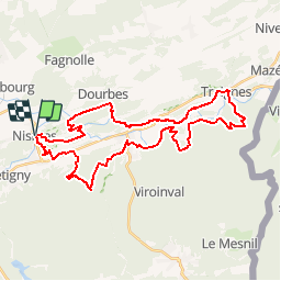
Viroinval en boucle

MathieuBourgois
User

Length
35 km

Max alt
326 m

Uphill gradient
1083 m
Km-Effort
50 km

Min alt
122 m

Downhill gradient
1083 m
Boucle
Yes
Creation date :
2019-01-15 20:36:33.571
Updated on :
2019-01-15 20:36:33.571
10h31
Difficulty : Difficult

FREE GPS app for hiking
 SityTrail
IGN / Geographical institutes
SityTrail Plus
The world is yours!
About
Trail Walking of 35 km to be discovered at Wallonia, Namur, Viroinval. This trail is proposed by MathieuBourgois.
Description
Nismes - Fondry des chiens - Olloy - Vierves - Treignes - Le Viroin
Positioning
Country:
Belgium
Region :
Wallonia
Department/Province :
Namur
Municipality :
Viroinval
Location:
Nismes
Start:(Dec)
Start:(UTM)
610845 ; 5548063 (31U) N.
Comments