Trail Walking Morbier - Les Briolettes - Photo
 tracegps
tracegps

User

© OpenStreetMap contributors
Length
Length
11.6 km
Max alt
Max alt
1154 m
Uphill gradient
Uphill gradient
401 m
Km-Effort
Km-Effort  
16.9 km
Min alt
Min alt
846 m
Downhill gradient
Downhill gradient
410 m
Boucle
Boucle
Yes
Creation date :
2014-12-10 00:00:00.0
Updated on :
2014-12-10 00:00:00.0

(1 Reviews)

Walking
Walking
3h30
Difficulty : Medium

Scan this QR Code to open this trail in the SityTrail application

FREE GPS app for hiking

Logo SityTrail SityTrail

IGN / Geographical institutes

Download SityTrail from the App Store Download SityTrail from Google Play

Logo SityTrail SityTrail World

The world is yours!

Download SityTrail from the App Store Download SityTrail from Google Play Download SityTrail on Huawei AppGallery

About

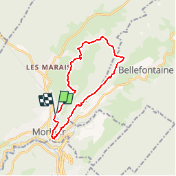
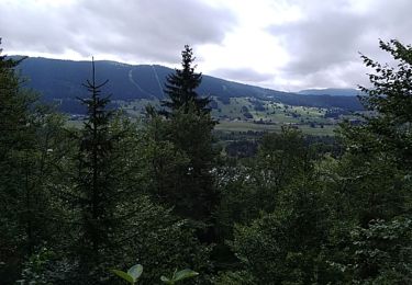
Trail Walking of 11.6 km to be discovered at Bourgogne-Franche-Comté, Jura, Morbier. This trail is proposed by tracegps.

Description

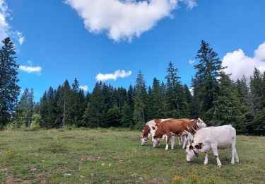
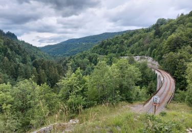
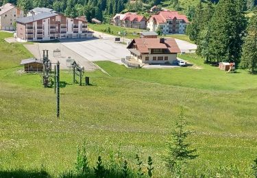
Tracé essentiellement forestier pour ce circuit qui permet de découvrir les alentours de Morbier, berceau du fromage du même nom et de l’horlogerie comtoise, avec 3 belvédères et un passage au dessus du viaduc des Crottes (sur la ligne ferroviaire des Hirondelles). Téléchargez la fiche du circuit en format pdf.

Elevation profile

Photos

Positioning

Country:
France
Region :
Bourgogne-Franche-Comté
Department/Province :
Jura
Municipality :
Morbier
Location:
Unknown
Start:(UTM)
271530 ; 5158684 (32T) N.

Comments

Please log in to post a review or rate the element


château des prés dimanche


Trails nearby

Trail Walking Bellefontaine - Des lacs de Bellefontaine vers le belvédère de la roche Bernard. - Photo
Walking
fizz1212

Walking

Difficult
Bellefontaine, Bourgogne-Franche-Comté, Jura, France
5.8 km | 8.7 km-effort
1h 53min
Yes
Trail Walking Bellefontaine - Autour de la citadelle. - Photo
Walking
fizz1212

Walking

Easy
Bellefontaine, Bourgogne-Franche-Comté, Jura, France
3.8 km | 5 km-effort
1h 4min
Yes
Trail Walking Bellefontaine - Le point de vue de la roche devant - Photo
Walking
fizz1212

Walking

Easy
(1)
Bellefontaine, Bourgogne-Franche-Comté, Jura, France
6.2 km | 8.9 km-effort
1h 51min
Yes
Trail Walking Hauts de Bienne - sentier de la Bienne - Photo
Walking
fizz1212

Walking

Medium
Hauts de Bienne, Bourgogne-Franche-Comté, Jura, France
4.7 km | 7.4 km-effort
1h 57min
Yes
Trail Walking Bellefontaine - La Côte  de Ci-Devant - Photo
Walking
Mady Lambert

Walking

Medium
Bellefontaine, Bourgogne-Franche-Comté, Jura, France
3.4 km | 4.7 km-effort
1h 25min
Yes
Trail Snowshoes Bellefontaine - Bellefontaine,roche devant, les Gentianes - Photo
Snowshoes
zefreefly

Snowshoes

Medium
Bellefontaine, Bourgogne-Franche-Comté, Jura, France
22 km | 30 km-effort
5h 17min
Yes
Trail Snowshoes Bellefontaine - Bellefontaine Chapelle de bois - Photo
Snowshoes
zefreefly

Snowshoes

Medium
Bellefontaine, Bourgogne-Franche-Comté, Jura, France
21 km | 26 km-effort
5h 33min
Yes
Trail Snowshoes Bellefontaine - Bellefontaine roche Champion - Photo
Snowshoes
zefreefly

Snowshoes

Difficult
Bellefontaine, Bourgogne-Franche-Comté, Jura, France
18.4 km | 26 km-effort
5h 12min
Yes
Trail Walking Les Rousses - Balade à pied .Lac des Rousses 29.07.2021 - Photo
Walking
lestetinesvertes

Walking

Medium
(1)
Les Rousses, Bourgogne-Franche-Comté, Jura, France
6.2 km | 9.9 km-effort
2h 0min
Yes


Close
My subscriptions