


Durbuy_Al roche kinet

denissculier
User
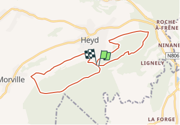

Length
8.1 km

Max alt
385 m

Uphill gradient
203 m
Km-Effort
10.8 km

Min alt
285 m

Downhill gradient
212 m
Boucle
Yes
Creation date :
2019-01-15 20:45:46.573
Updated on :
2019-01-15 20:45:46.573
2h18
Difficulty : Medium

FREE GPS app for hiking
 SityTrail
IGN / Geographical institutes
SityTrail Plus
The world is yours!
About
Trail Nordic walking of 8.1 km to be discovered at Wallonia, Luxembourg, Durbuy. This trail is proposed by denissculier.
Positioning
Country:
Belgium
Region :
Wallonia
Department/Province :
Luxembourg
Municipality :
Durbuy
Location:
Heyd
Start:(Dec)
Start:(UTM)
682534 ; 5579645 (31U) N.
Comments