


Gendron (Houyet)

denissculier
User
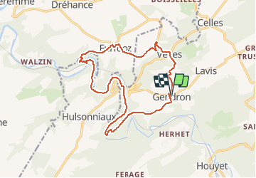

Length
14.6 km

Max alt
240 m

Uphill gradient
347 m
Km-Effort
19.2 km

Min alt
99 m

Downhill gradient
344 m
Boucle
Yes
Creation date :
2019-01-15 20:46:26.86
Updated on :
2020-11-30 16:49:20.876
4h09
Difficulty : Difficult

FREE GPS app for hiking
 SityTrail
IGN / Geographical institutes
SityTrail Plus
The world is yours!
About
Trail Nordic walking of 14.6 km to be discovered at Wallonia, Namur, Houyet. This trail is proposed by denissculier.
Positioning
Country:
Belgium
Region :
Wallonia
Department/Province :
Namur
Municipality :
Houyet
Location:
Celles
Start:(Dec)
Start:(UTM)
641779 ; 5563675 (31U) N.
Comments