


69 RONTALON Les Ravières

trietsch
User
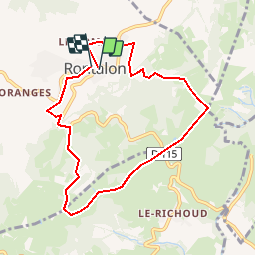

Length
8.1 km

Max alt
619 m

Uphill gradient
299 m
Km-Effort
12 km

Min alt
406 m

Downhill gradient
291 m
Boucle
Yes
Creation date :
2019-01-15 20:49:32.244
Updated on :
2020-01-04 20:28:27.972
2h31
Difficulty : Unknown

FREE GPS app for hiking
 SityTrail
IGN / Geographical institutes
SityTrail Plus
The world is yours!
About
Trail Walking of 8.1 km to be discovered at Auvergne-Rhône-Alpes, Rhône, Rontalon. This trail is proposed by trietsch.
Positioning
Country:
France
Region :
Auvergne-Rhône-Alpes
Department/Province :
Rhône
Municipality :
Rontalon
Location:
Unknown
Start:(Dec)
Start:(UTM)
627263 ; 5057606 (31T) N.
Comments