


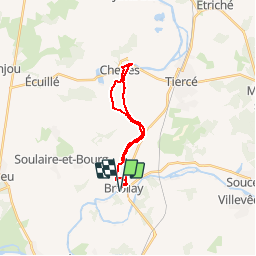
Au fil de la Sarthe - Briollay

tracegps
User


4h15
Difficulty : Difficult

FREE GPS app for hiking
 SityTrail
IGN / Geographical institutes
SityTrail Plus
The world is yours!
About
Trail Walking of 18.1 km to be discovered at Pays de la Loire, Maine-et-Loire, Briollay. This trail is proposed by tracegps.
Description
Le syndicat d'Initiative de Briollay, vous propose 4 sentiers de randonnée balisés sur la Commune : - Au fil de la Sarthe ( 16 km), - Les prairies alluviales (15,5 km), - De Vérigné à la Rochefoulques (12 km), - Le marais (5km). Retrouvez ces sentiers dans le guide «Le Plaisir en Marche» qui est en vente au Syndicat d'Initiative.
Photos


Positioning
Comments
une belle balade toute tranquille
oui