


thoronet Ref

vincente204
User
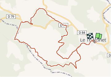

Length
15 km

Max alt
306 m

Uphill gradient
404 m
Km-Effort
20 km

Min alt
137 m

Downhill gradient
405 m
Boucle
Yes
Creation date :
2019-05-06 10:06:09.493
Updated on :
2019-05-06 10:06:09.493
6h24
Difficulty : Unknown

FREE GPS app for hiking
 SityTrail
IGN / Geographical institutes
SityTrail Plus
The world is yours!
About
Trail Walking of 15 km to be discovered at Provence-Alpes-Côte d'Azur, Var, Le Thoronet. This trail is proposed by vincente204.
Description
moyenne
Positioning
Country:
France
Region :
Provence-Alpes-Côte d'Azur
Department/Province :
Var
Municipality :
Le Thoronet
Location:
Unknown
Start:(Dec)
Start:(UTM)
281779 ; 4814433 (32T) N.
Comments